Form Road Longsection and Cross sections
Creates a Longsection and cross sections using a string and the digital terrain model (triangles).
It will interpolate LS points along the string at regular intervals and will extract cross sections
at those points where possible.
String
Select the string with the mouse to be extracted
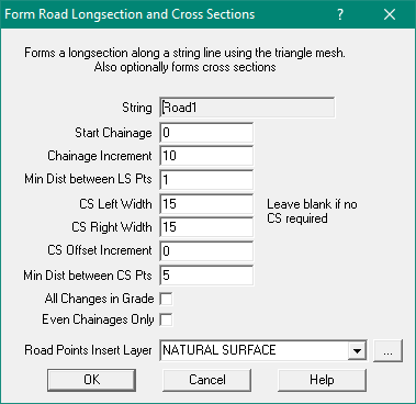
Start Chainage
Enter the chainage of the point to start the extraction
Chainage Increment
This is the interval between successive interpolated long section (Cross section) points.
Min Distance Between LS Points
When an interpolated point lies too close to an existing String point, it will not be extracted.
This is the minimum tolerance distance from an existing point.
Cross Section Left Width
When a cross section is extracted, it will be projected at 90 degrees to the longsection to the left and the right
This is the distance that the left side will be projected.
Cross Section Right Width
When a cross section is extracted, it will be projected at 90 degrees to the longsection to the left and the right
This is the distance that the right side will be projected.
CS Offset Increment
If entered, it will only insert points at regular intervals, the offset increment
Min Distance Between CS Points
When an interpolated point lies too close to an existing CS point, it will not be extracted.
This is the minimum tolerance distance from an existing point.
All Changes in Grade
Tick this box to add a point every time the lines cross a triangle.
As the longsection and cross section lines are projected through the triangles,
this option will interpolate points at every triangle edge, thus at every change of grade.
Note that cross sections will only be created at the ‘even chainage’ point on the longsection.
Even Chainages Only
Tick this box to only allow even chainage points inthe Longsection, others are deleted.
General information and Frequently Asked Question.